


- By Katrina Binkewicz
- News
 Print
Print 
| Last March the Lansing Town Board authorized up to $5,000 for lead testing in and around Salmon Creek from Ludlowville to the creek outflow area. Town Supervisor Ed LaVigne says he would prefer the testing be done by independent soil samplers and lab to remove any doubt about the findings. But Councilwoman Katrina Binkewicz said that she and Councilwoman Andra Benson would collect samples to be analyzed by a local laboratory. Full data and report on the Town Web site | ||
Sampling in the stream sediment and on DEC land required permission. Town Board members (Joe Wetmore and Katrina Binkewicz) contacted the proper local department and were asked to submit a request for permission to sample at the mapped sites. A formal permit was not required. Permission was granted by the DEC to sample on Salt Point and in the stream sediments at the mouth of Salmon Creek in the alluvial fan, on the bank where dredging occurred, and in the Ludlowville Falls stream bank areas as long as the sampling was shallow (<4” depth) and did not muddy the water. Control sampling North on the bank of Salmon Creek was obtained with permission of the landowner (Suzie Hinderliter).
Soil Sampling Procedure
To obtain the correct sampling protocol, I called -The Cornell Nutrient Analytical Lab, School of Integrative Plant Science-Section of Soil and Crop Sciences, Cornell University, 804 Bradfield Hall, Ithaca- and asked for their preferred standardized procedure. Michael A. Rutzke explained the collection procedure. I ‘grab’ collected samples in the surface 4 inches of soil or sediment by searching for areas where there were finer sediments in the coarse sand to silt particle diameters. I scooped an array up on a steel shovel and brushed away the coarser gravel and organic particles. When I had achieved a more consistent sample, I poured it into the zip-lock sandwich bag and labeled the bag with the sample number, collection area code letter, and took a GPS coordinate for that sample. During the sample collection process, I performed a visual inspection for any shot pellets or lead sinkers. At no time in the sampling process did I find any of these in a recognizable state. I was the only one who took the samples in order to maintain a consistent sampling methodology. The approximate locations of samples taken are found on the attached maps.
During the sampling process observers assisted by writing the GPS coordinates down in order to speed up the process and verify standardization. At no time were the samples out of my possession. When the sampling was completed, I delivered them to the lab myself. Upon delivery, we reviewed the samples and the staff’s ability to correctly read my codes and I signed the contract to perform the analyses for the Town of Lansing.
Sampler: Katrina Binkewicz
Observers: Myers Park and Salmon Creek Bank- Andra Benson and Tony Greenly, Salt Point- Matthew Binkewicz, Ludlowville Falls- Steve Smith
Observers: Myers Park and Salmon Creek Bank- Andra Benson and Tony Greenly, Salt Point- Matthew Binkewicz, Ludlowville Falls- Steve Smith
Soil Processing Procedures
Lab Staff: Michael A. Rutzke, Dawn Moser, Tatyana Dokuchayeva
In the lab, the samples were labeled with a number and code. The soils were dried and screened (2mm). During this process the screenings were examined for signs of any shot pellets or sinkers as well. None were found. The dried soil was pulverized in order to remove clumps and further blend the remaining sample. The soil sample was treated with a triple acid treatment to dissolve organics and all metals present (nitric acid, chloric acid, and hydrochloric acid). The laboratory process is described below.
Vulcan 84 Soil Digestion with HF
About 0.50 grams of soil is weighed into 74 ml Teflon containers. Containers are placed in the automated Vulcan 84 digestion unit manufactured by Questron Technologies in Mississauga Canada. The samples are digested with nitric and perchloric acid using the following procedure.
While the tubes are in the raised position a robotic arm and syringe pumps add 5.0 ml of nitric acid and 4.0 ml of perchloric acid plus 2.0 ml of hydrofluoric acid. The tubes are lowered into the blocks and heated to 180 degrees centigrade gradually over 30 minutes. The temperature is held at 180 degrees centigrade for 20 minutes. The tubes are then raised and cooled. Using a 50 ml dispenser with a Teflon plunger 50.0 ml of 18 meg water is added to each container.
The solutions are then analyzed for their elemental composition using a Spectro Arcos axial viewed ICP-OES. The instrument is manufactured in Kleve Germany by SPECTRO Analytical Instruments Inc. a division of AMETEK® Materials Analysis. Manufactured January 2013.
The soil was tested in the lab for a range of substances including lead (PB). Upon receiving the report, I copied the sample codes and lead levels to a new spreadsheet so that I might add pH data for each sample.
Notes on Data Collection- See Maps Below
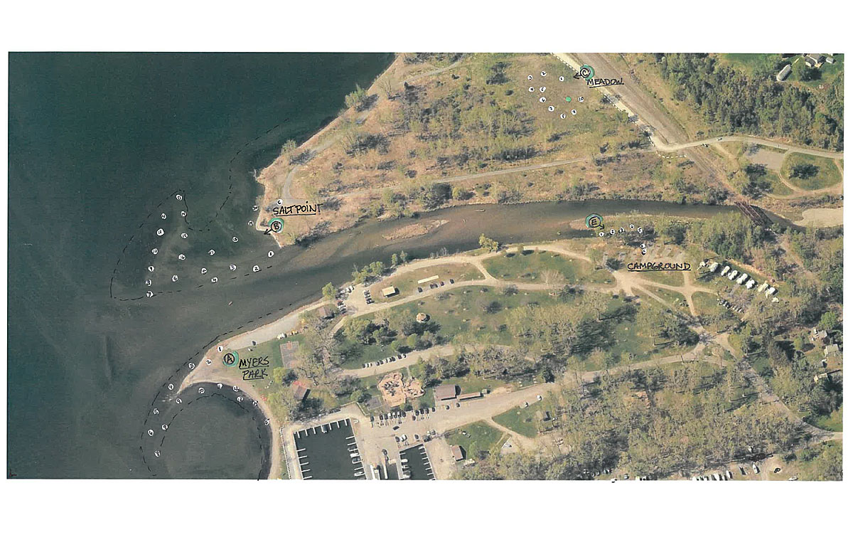
A samples- Collected at tip of Myers Point, starting at the N. West end parking lot, looping along SW outside edge of the exposed winter gravel bar to mid swimming area, then back along the inside around the beach almost to the lighthouse breakwater.
B samples- Collected from the edge of the stream at the Salt Point SW beach (by the bench), along the stream edge at winter lake level West to the edge of the large gravel bar, then along the West facing edge of that bar heading North, back along the inside edge of the bar and heading back to the beach at the second bench. B Control- gravel path West end of Salt Point.
C samples- Collected from meadow edge by blocks, over to the North side of disturbed area, South along the Wet edge of meadow, then across the meadow East.
D Samples- Collected from Salt Point dredge piles that had been moved to the Highway barn storage area. These samples have been transferred several times by backhoe, truck and bulldozer. Many points of potential contamination. Lead numbers are still low.
E samples- Collected from the Salmon Creek dredge area and bank on the South bank by the Myers Park campground. E Control- soil in campground area.
CSC samples- (Control Salmon Creek) Collected from the stream edge at flood height on the Hinderliter property North of Lockerby Hill Road.
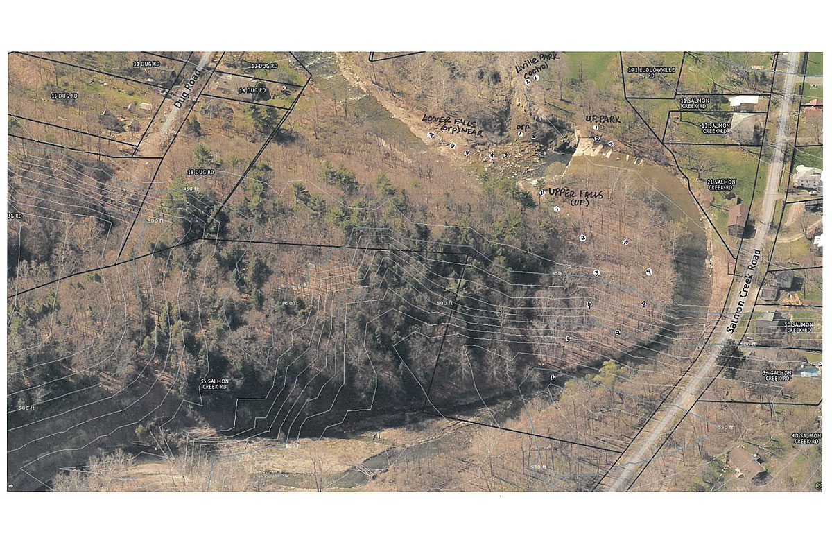
UF samples- (Upper< Ludlowville Falls) Collected above the falls in the interior of the oxbow flood channel, then along the stream side back to the falls.
LF samples- (Lower< Ludlowville Falls) Collected from the base of the falls flood height down to the boulder, along edge of stream, back through woods at flood height. LF Control samples- collected higher on the slope above flood height. C2 in area of old dwelling.
LF orp samples- (Lower< Ludlowville Falls, Park side) 2 samples taken at base of falls cliff under overlook area.
Park Lville Control- samples taken in Ludlowville Park by the pavilion. Note*many mills and buildings were on site in 18-1900s.-potential source of residual lead. Also site of old rusty playground equipment.
UF near samples- collected just above falls on creek edge on the Park side.
Summary Notes (re: lead):
All samples exhibit levels of lead consistent with naturally occurring soil lead levels in this area (according to lab personnel, 30-100ppm). Range includes all samples. Outliers in parentheses. Mean includes outliers, therefore skewed high.
There are some higher lead levels that show up as outliers in some sampling groups:
42.8- Upper Falls #11- at site of early millworks dam
46.7- Lower Falls opp. #7 was collected closer to house and could have been in area of old outbuildings.
43.1, 61.8, - L. Falls near #1, #2 were collected high on the bank above water flow, probably representative of soil deposited from mills in the park zone. #4-#7 were collected from stream edge sediment
57.6- Ludlowville Control #2 collected from a dirt pile at the edge of the park in the woods near the pavilion. Probably residue from when the old rusty playground equipment was removed.
All samples are significantly below Cornell University soil lead safety recommended levels for both Ag. < 100mg/kg and Home garden- < 400mg/kg. These levels apply to soils with a pH of 6 or above.
PH for all samples were between 6.99-8.71 except one (9.53). The pH of the water that contacts with any lead is relevant. The form that lead takes, elemental or as a particular compound, is also an important component of how readily lead may leach or mobilize from the soil it is in.
DEC Division of Environmental Remediation sets different standards for soil and sediment depending on the clean-up objectives for various constituents based on the uses of the property and the pH of the soil- See regulations at 6 NYCRR 375-6.8(a) and (b). The Unrestricted Use soil standard for lead is 63 ppm in that regulation. The ‘Screening and Assessment of Sediment’ guidance document by DEC dated June 24,2014 suggests that lead in sediment below 36ppm to be” low risk to aquatic life”
Summation
In the Sampling Areas, the soil lead levels are all under standards even for growing edibles. The data collected does not indicate widespread soil contamination. In my opinion, the lead levels do not indicate the need for further testing down stream of Ludlowville Falls. There has certainly been a great deal of lead that has been deposited in spent shot on the Rod and Gun Club site. This data suggests that the lead is staying on site.
It would be helpful for the Town Board to know what the levels of lead are in the soil along the stream as it passes through the Rod and Gun property past the old shooting range site. Collecting further soil samples from the stream as it approaches the shooting range could provide solid evidence that supports the theory that the lead is staying on or near the deposition area. This testing cannot occur unless permission is granted by the Lansing Rod and Gun Club because the stream passes through their property.
Because Salmon Creek is a managed NYS fishing stream of note, it is imaginable that there may be spot contamination from a lead pellet or lost lead sinkers. It is advisable to watch small children closely so that they do not ingest particles while at the stream or at shore areas.
***If there are additional questions please submit them to the Town Supervisor, Ed Lavigne. A follow-up discussion will be held at a date yet to be determined.
v15i22